Butterfly configuration - Polish proposal for satellite missions
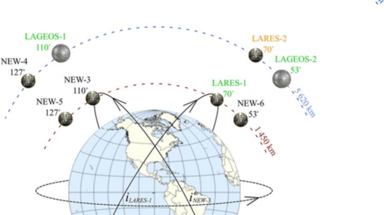 Figure from the Wrocław University of Environmental and Life Sciences press release
A team of scientists from the Wrocław University of Environmental and Life Sciences proposes placing geodetic satellites in a 'butterfly' configuration, including satellites in retrograde orbit, where there are currently no objects orbiting the Earth.
'Butterfly configuration is very beneficial in the study of global changes, including: changes in rotation or the flattening of the Earth caused by the melting of glaciers at the poles,’ say the authors of the paper in the Journal of Geophysical Research: Solid Earth.
In a press release, Joanna Najder, Krzysztof Sośnica, Dariusz Strugarek and Radosław Zajdel explain that artificial satellites are usually placed in circumpolar orbits, with an angle of inclination relative to the equator of about 90 degrees; they are then used, for example, to observe changes in the polar regions.
They can also be placed in orbits with lower inclination angles, such as 55 degrees for GPS, or 56 degrees for Galileo, or 0 degrees for geostationary satellites. The researchers emphasize that there are almost no satellites orbiting the Earth at angles of inclination from 120 to 180 degrees. Placing a satellite in a retrograde orbit above 90 degrees is much more expensive. Meanshile, placing satellites at an angle of less than 90 degrees is helped by the Earth's rotation, thanks to which less fuel can be used to launch the object into orbit.
FAVOURABLE RETROGRADE ORBIT
'As it turns out, the so-called retrograde orbit, in which satellites move against the direction of Earth's rotation, is favourable for studying our planet. During the same period, satellites in retrograde orbits make more passes over the same areas relative to the observer on Earth. Satellite flights are shorter, but more frequent than in standard orbits,’ the scientists say.
Their simulations show that it is best to use retrograde orbits to better understand global processes and their changes over time. 'Thanks to such orbits, it is possible to better determine changes in the flattening of the Earth, which are caused by the melting of glaciers in Greenland and Antarctica, changes in the position of the pole and changes in the centre of gravity of the planet's mass, i.e. the point around which all artificial satellites orbit,’ the researchers say.
BUTTERFLY CONFIGURATION
Simulations allowed them to identify the optimal orbit for future geodetic missions. The scientists proposed supplementing the existing configuration of the LAGEOS and LARES geodetic satellites with new satellites that would allow the configuration to remain symmetrical relative to the Earth's rotation axis. This creates a butterfly configuration.
'For example, for a satellite tilted at an angle of 70 degrees to the pole, a satellite at the same altitude tilted at an angle of 180-70=110 degrees to the pole is proposed. Both the first and second satellites will orbit over the same areas of the Earth, but the latter, in a retrograde orbit, will move opposite to the rotation of the planet, the researchers explain in their paper.
In their opinion, the butterfly configuration has many advantages. It makes it possible to effectively separate various effects observed in the motion anomalies of artificial satellites (which are indistinguishable in the case of a single satellite) and thus better understand the processes occurring on Earth and causing these anomalies.
OPTIMALLY PLACED GEODETIC SATELLITE
The most optimal place to place the future geodetic satellite turns out to be an inclination angle of 127 degrees and an altitude of 5,620 km. 'This configuration provides a mirror image of the orbital parameters of the LAGEOS-2 satellite in a butterfly configuration. A satellite moving in retrograde orbit will have an orbital period relative to a station on the rotating Earth of 3 hours 13 minutes, while the LAGEOS-2 satellite has the same orbital period of 4 hours 22 minutes, despite the same altitude', the researchers calculate.
Thanks to this, as they explain, the laser station located on Earth will be able to register more satellite passes during the day (on average 36 percent more), and the satellite will 'scan' the Earth's surface better because it will make more passes during the same time.
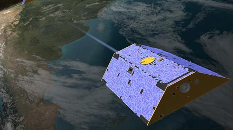
Geodetic satellites have the shape of a ball and are equipped with reflectors that reflect the laser beam in exactly the same direction as the direction of the incident beam. This enables very accurate distance measurements from ground-based telescopes. Such satellites constitute the basis for studying changes in the shape of the Earth caused by processes occurring in the atmosphere, land hydrology, oceans and the Earth's crust, and allow to determine changes in the position of the pole.
'However, the satellites launched so far have not always been placed in the most favourable places, as there are no satellites with an inclination angle larger than 110 degrees. Therefore, despite the higher costs of launching satellites, it is worth placing them where they currently do not exist - in retrograde orbits,’ the researchers say.
PAP - Science in Poland
kol/ agt/ kap/
tr. RL
Przed dodaniem komentarza prosimy o zapoznanie z Regulaminem forum serwisu Nauka w Polsce.