European geohazard information service PanGeo is online
A unique website, showing the geological hazards for 52 European cities, including Warsaw and Nowy Sącz, is online. Polish Geological Institute (PGI-NRI) participated in the work - told PAP the institute spokesman.
Geohazards presented on PanGeo (www.pangeoproject.eu) include earthquakes, landslides, ground movement caused by exploitation of groundwater, deformation of clays, karst processes , soil creep and rock collapsing. Information on each of the cities is presented in a uniform format, allowing to compare the situation of different places in Europe.
The list of 52 monitored locations contains two Polish cities: Warsaw and Nowy Sącz. Neither of them faces any serious threats. The observed rate of subsidence is up to several millimetres per year. There are, however, spots of more significant movements related to the geological structure or the passageways.
"Experts from the Polish Geological Institute are working on further cities that will be added to PanGeo. They are also open to suggestions of residents and municipal authorities, as to the areas that need to be interpreted and incorporated into the service materials" - said the Polish Geological Institute spokesman Mirosław Rutkowski.
The online geohazard information service PanGeo was created in cooperation of 27 national geological survey institutes and ten professional organizations. Over three years, a database has been compiled that allows to evaluate the dynamics of soil surface movements and potential geological hazards in 52 European cities.
Map data at 1:10,000 scale can be viewed through the PanGeo browser or on Google Earth, as well as downloaded and integrated into the user\'s information service. According to the authors, PanGeo can be useful to local governments of cities, crisis management services, and planners.
The Polish Geological Institute spokesman noted that the urban environment is not very friendly, not only because of the noise, fumes or heavy traffic. Cities also suffer from problems associated with the geological structure of the substrate. The choice of location is not always rational, as shown by the example of Venice. Its buildings were erected on a practically unsuitable site. As a result, the city subsides a few inches every year and chances to save it in the long run are small. Subsidence (the slow motion of a surface shifting downward) is the problem that plagues not only Venice. Soil burdened with massive structures, subjected to vibrations in the vicinity of roads, and often unstable due to dehydration, subsides in all European cities.
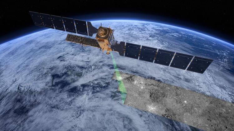
"Until recently, the rate of subsidence could be assessed only by effective, but expensive surveying. For several years now, we can do it much cheaper thanks to satellites" - emphasised Rutkowski. He explained that satellite radar systems can detect millimetre ground shifts from an altitude of about 700 km. Thanks to the orbit properties, satellite can take images of the same piece of land every few days. Digital recording of characteristics of the reflected radar beam allows to compare multiple images of the same area and its characteristic, fixed points. This in turn allows to assess the rate of subsidence. The technology called synthetic aperture radar interferometry (InSAR) has become a tool in many fields of economy and science.
Since 2002, the European Union uses data supplied by the satellites of the European Space Agency (ESA) in the framework of Global Monitoring for Environment and Security (GMES). The Polish Geological Institute is involved in this project since 2003 through programs Terrafirma, DORIS , SubCoast and PanGeo. "The result of our activities are cartographic presentations of the Upper Silesian Coal Basin, Baltic Sea coast, landslide areas of the Carpathians and tectonics of salt domes in the area of Inowrocław" - emphasised Rutkowski.
PAP - Science and Scholarship in Poland
zan/ krf/
tr. RL
Przed dodaniem komentarza prosimy o zapoznanie z Regulaminem forum serwisu Nauka w Polsce.