A drone helped discover traces of ancient human activity in Orkney
Polish scientist using a drone discovered unknown relics of ancient human activity. He also created maps of inaccessible archaeological sites on the main island of Orkney - Mainland, in northern Scotland.
"The objective of my work was to make maps of three potential archaeological sites in Orkney. In two cases, measurements confirmed that these were in fact archaeological sites - until now, Scottish researchers were not sure" - told PAP Kasper Hanus, PhD student at the Institute of Prehistory, Adam Mickiewicz University in Poznań. The trip and research were financed with funds awarded by the Foundation for Polish Science within the framework of the START scholarship.
Local professionals involved in the protection and management of heritage in Orkney do not have drones in their inventory. Therefore they partnered with the Polish scientist, and identified a few places for flights and testing the drone in harsh weather conditions. Alleged archaeological sites are located on outlying narrow promontories, whose vertical cliffs are very dangerous for people doing surface research - after hundreds of years, ocean more deeply penetrates the coast.
This allowed to register hitherto unknown traces of ancient human activity. In the case of the Burwick site, photos taken with a drone allowed to notice a fragment of remains of am embankment, which protected the peninsula from the mainland. In Harwick the archaeologist located a mound, which in his opinion may be a remnant of buildings from the late prehistory.
"Thus, through the use of low ceiling aerial photographs, we were able to find potential remnants of ancient human activity in the landscape" - added Hanus.
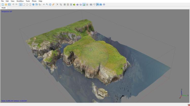
The third place of the research was Brough of Deerness, where the relicts of medieval chapel are located. During earlier excavations archaeologists also discovered buildings from the VI-IX century. Images taken from a drone during this year\'s flights show more than 15 structure outlines, which until now have not been studied - the colouration and height of the grass that grows on the old stone walls differs from the environment, which is clearly visible from the air.
"Drones are the ideal devices to survey areas that are difficult to reach, such as in this case - high, steep headlands cutting deep into the ocean. The biggest challenge was to control the device, because the wind in this region can be very strong" - concluded Hanus.
PAP - Science and Scholarship in Poland
szz/ zan/ mrt/
tr. RL
Przed dodaniem komentarza prosimy o zapoznanie z Regulaminem forum serwisu Nauka w Polsce.